|
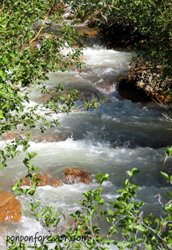
附註: http://www.localhikes.com/Hikes/MillCreekFalls_0000.asp Mill Creek Falls is the tallest waterfall in Lassen Park, and is arguably the nicest. The hike is moderate, mostly up and down hiking all the way. The trail brings you to an overlook of the waterfall, where you get a great view of the falls. Continue on the trail, and take a short spur to the top of the waterfall. This is a great place to have lunch and look (but not too closely) over the ledge. The fall's flow is best in June or July, but it still flows well
into August. Highlights: pretty meadows, mountain views, 75 ft. waterfall Distance: 3.6 miles round trip (Actually 應該是4.6 miles out and back, 大部份的網站提供的資料是4.6 miles, 如: http://www.lassen.volcanic.national-park.com/hike.htm) Elevation Gain: 800 ft Hike Time: 2 hours (我們來回花了3 個多小時, 除了肉腳的原因之外, 也有部份是因為我老在半路停下來拍照, 又看野花又找磨菇, 消磨太多時間) Difficulty: Moderate Trail Condition: Well maintained trail (真的嗎? 除了部份路段被雪埋住, 要找一下之外, 還有些路被路倒的樹擋住, 要繞道或爬過去耶) http://gorp.away.com/gorp/resource/us_national_park/ca/hik_la.htm Mill Creek Falls: 4.6 miles round trip, downhill about 300 feet and uphill about the same. Hike features highest waterfall, forest and flowers. http://www.americansouthwest.net/california/lassen_volcanic/mill_creek_falls.html Mill Creek Falls are the highest in Lassen Park - here the creek drops over 100 feet as it flows along a narrow valley, eventually joining the Sacramento river. The falls are reached by a 1.5 mile foot path, starting close to the campground at the southwest Park entrance, that encounters no volcanic features, just pretty meadows with wildflowers and varied vegetation, pine woods and small hills. The path crosses several streams and has a few steep sections, but without much overall elevation change. Near the start, the path passes a large field of sunflower-type plants on a sunny hillside, typical of the scenery of this area. The Falls: The tall, narrow falls are first visible from a viewpoint at the edge of a cliff opposite. The path beyond curves down to the very edge of the noisy cascading water - from here one can see for some distance along the steep V-shaped valley downstream. The Creek: It is almost possible to jump over the river just above the falls, where the watercourse narrows and flows through a deep channel, but it can be crossed in safety by fording the creek about 20 metres upstream. On the far side, a small stream joins just above the falls and from the rocks near here one can see that the water actually drops about a third of the way into a rocky pool, cut into the cliffs, then spills out and falls to the canyon floor. The water in the creek is quite acidic, resulting from sulphur contamination upstream in the thermal areas where the water originates. |
|

上一頁 || Mill Creek Falls Trail
| 1 | 2 | 3
| 4 | 5 | 6
| 7 | 8 | 9
| 10 | 11 | Note
|| 回目錄 | 回首頁 | 下一頁
永遠的胖胖 版權所有 ©2005 www.ponponforever.com